
Archaeology is a broad discipline, with a multitude of subsects and specialisations. One of these is buildings archaeology, where we use archaeological methods to record and analyse buildings and see what that can tell us about the people that constructed them. We’ve written various blogs before about some of the different houses that we’ve recorded, and while this blog is also within the realm of buildings archaeology, it’s also quite different to those other blogs. Part of our work as archaeologists is to place things within the historical context of the period that they date to. If we were excavating a Roman villa and we found glass windowpanes, then we’d be interpreting that villa as probably belonging to a pretty wealthy individual. However, when we find window glass in Christchurch, that doesn’t really tell us anything about the status of the person that built that house, as window glass was readily available and used in the majority of buildings. We’re really lucky as historical archaeologists that there are large historical datasets that we can use to help us with determining the context of the period that our sites date to. However, there’s hours and hours of research that goes into building a database from raw historical data, and even more hours spent looking at patterns and trends to help us establish that historical context.
Returning to buildings archaeology, one of the key elements that we look at when we record a building is what it was made from. Here in Christchurch, that’s almost always timber. From our recording, we know what types of timbers were typically used here in Christchurch for houses, but that’s only half the story. By doing detailed historical research on the timber industry, we can find out if there were patterns in what species were available for purchase and then use that historical information to provide more context to what we find in the archaeological record. It all sounds so simple, but let me tell you it’s not. I’ve spent countless hours doing research into the Christchurch timber industry, and I’ve only gotten through the first 20 years. That period is going to be the focus of this blog.

That sure is some nice timber, I wonder where it came from?
Prior to 1850, the year that the city of Christchurch was founded, the Canterbury Plains were largely devoid of forests. Although opinion is divided on the exact extent of forested area in Canterbury at the time of Pākehā settlement, Roche (1990) estimates that the combined forest area in the Canterbury settlement added up to only 240,000 acres, or 12 % of the total land area (Roche 1990: 75). Near Christchurch there was a small forest of 54 acres where Christchurch’s most notable pioneers, the Deans brothers, established their Riccarton farm in 1843 (Orwin 2015: 25-26). The largest areas of forest were located some distance away. These included the native podocarp forest of Banks Peninsula, comprised mainly of matai (then known as black pine), kahikatea (white pine) and totara (for some reason just known as totara); and the mixed podocarp and beech forest at Harewood Forest, with kahikatea, rimu (red pine), matai and totara, with silver and black beech (they called it birch back then and were big time into their colour naming system; Roche 1990a).

Map of bush cover in Canterbury collated and reconstructed from 1850s and 1860s surveyor’s notebooks and maps by W. B. Johnson and redrawn for Pawson and Holland (2005: 171).

An 1851 sketch of the upper reaches of the Waimakariri River showing Harewood Forest, one of the largest areas of bush close to the city of Christchurch. Image: Fox, W. and Allom, T., 1850-1851.
Suitable building timber was not readily available in Christchurch and so Canterbury’s pioneer settlers built their houses from materials that they either brought with them from elsewhere, such as canvas, calico and sheets of iron to form tents and rudimentary temporary dwellings, or resources that might have been available on or near their chosen sections. These included volcanic stone, rammed earth, sod or mud brick for the walls and thatched or slab roofs made from raupo, toetoe, tussock, or bark (Bowman 1941, Isaacs 2015, Salmond 1986). In areas where timber was more plentiful wooden slabs or logs were used to build basic wooden structures, but even then, some timber had to be imported because of the difficulty in getting the logs milled once they were cut down.
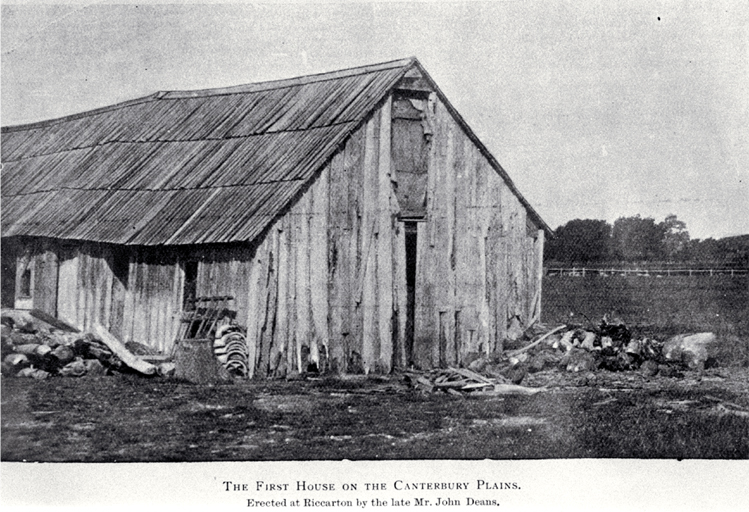
Although it was located right beside one of the largest stands of forest near Christchurch, Deans Bush, the first house on the Canterbury Plains built by the eponymous Deans brothers was constructed from framing timber that they brought with them from Wellington (Bowman 1941).

Photograph of the first house built by the Deans brothers near Riccarton Bush in 1843. The house was built with timber brought from Wellington but was dismantled in the late 1890s. Image: Canterbury Times, 1900.
With the founding of Christchurch city and the rapid expansion of its Pākehā population, an increasing number of settlers had to obtain the materials they needed to construct their permanent residences, fuel their fires, and fence their farms. Although Canterbury was comparatively bereft of a sustainable supply of timber, wood was still the dominant building material for houses in Canterbury in the nineteenth century (Government Statistician, Registrar-General’s Office 1874). This all led to the establishment of a burgeoning timber importation trade (Roche 1990).
Banks Peninsula was the largest and most easily accessible source of timber close to Christchurch, meaning this region was one of the major suppliers of building timber and firewood to the colony. If you want to read more about sawmilling on the peninsula and what happened after the timber arrived in Christchurch, I highly recommend that you read Lydia’s excellent post on the topic from earlier in the year. The timber supply from Banks Peninsula was, however, short lived and the capacity to saw and ship it was limited, so in this post we’re going to explore exactly where Christchurch got all its wood from.
By combining the magic of PapersPast and the dark arts of Excel, I tracked the ups and downs of the Canterbury’s timber economy over the first few decades of Pākehā settlement in Christchurch to figure out where the town was getting its timber from and how this changed over time.
January 11, 1851, was the first issue of the Lyttelton Times to be published and the first issue to include a list of vessels that had arrived in Lyttelton Port since the previous December, including the first four ships carrying the pioneer settlers and all of their possessions to Lyttelton (Lyttelton Times 11/1/1851: 5). Included was a schedule of the cargo each vessel carried, with the schooner, Phoebe, the first reported timber carrying vessel arriving from Wellington carrying a load of timber. For the first few years of settlement Wellington was to be the predominant supplier of Canterbury’s timber.

Not the Phoebe. Also not Lyttelton, but this is probably what it looked like when the first load of timber arrived in Lyttelton. Image: Frederick Nelson Jones.
Although several gangs of pit sawyers had established themselves in many of the bays of Banks Peninsula by this time, their contributions to the overall timber supply in the first years of settlement were negligible in comparison to other regions. Timber imports soon picked up though, as did the quantity of timber arriving in the city from Banks Peninsula. By the mid to late 1850s, imports from Tasmania were contributing a significant quantity of timber to the market, and from the early 1860s vessels from North America and the Baltic region were bringing large cargoes of Northern Hemisphere timber, such as Baltic pine, Douglas fir and cedar.
Within the first ten years of the arrival of the settlers, timber imports had increased considerably. This coincided with an increase in the population of Canterbury, as well as the number of wooden dwellings that were being built. This was a pattern observed across the study period, although population tended to increase in a more or less linear fashion, while timber imports fluctuated more but trended upwards almost exponentially overall.
A steep decline in the quantity of timber being imported to Christchurch and Lyttelton occurred in the late 1860s. There were several factors that probably contributed this. The population had continued to grow, and wooden dwellings were also being constructed at an increasing rate, so it was not likely a lack in demand for house building materials. The market commentary in the newspapers around this time suggests that the timber supplies were overstocked, likely due to huge shipments arriving from overseas and the from the Nelson and Marlborough region. On several occasions in 1866 newspaper correspondents reported that the timber market was depressed, Sales were low and likewise timber prices had tanked (Lyttelton Times 7/7/1866: 2, 2/11/1867: 2). This glut in the market likely caused timber merchants to refrain from importing new stocks until the oversupply had diminished and prices had increased. Due to the time lag between orders and shipment this reduction in imports was not fully realised until 1867-1868.

Customhouse Street wharf area, Wellington, circa 1868, with the harbour and Queens wharf in the background. The sailmaking premises of John S Burn, a boat under construction, and a timber yard, are visible. Couchman, (Mrs), active 1967. Customhouse Street wharf area, Wellington. Ref: 1/2-029401-F. Alexander Turnbull Library, Wellington, New Zealand. /records/22751906
A notable shift in the regions supplying timber occurred after 1864. Shipments from the Wellington and Auckland/Northland regions declined towards the late 1860s, but were replaced with considerable supplies from the upper South Island. Imports from the West Coast were non-existent until around 1867, which coincided with the end of the gold rush in this region. The milling industry in Westland was initially established in order to supply the requirements of gold miners, but, after the rush was over, had expanded significantly. By the 1870s the West Coast milling industry was supplying sawn timber to other regions, including Canterbury, as well as a thriving trans-Tasman export trade (Roche 1990a: 179).
While mainland Australia was a consistent, albeit minor, contributor to timber imports over the study period, Tasmania remained an important supplier to the Canterbury timber economy, from the first cargoes that arrived with the pioneer settlers in 1850, up until at least the early 1870s. It is likely that most, if not all of the timber that was imported from Tasmania at this time was harvested by convict labour. From 1804 convicted felons were transported to Van Diemen’s Land, as it was then known, and forced undertake hard labour while also forming a founding population for the new British colonies. Convict labour was employed in the harvesting of timber, a task that served both as punishment and progressed the economic ambitions of the colony by generating an exportable commodity, which found a ready market in Christchurch (Tuffin and Gibbs 2020; Tuffin et al 2020).

The original human centipede? Convicts hauling a log at Port Arthur c.1836. Image: State Library of Victoria: ML 185.
The predominant target species were varieties of Eucalyptus, mainly stringy bark and blue gum. Stringy bark was favoured for construction and blue gum was used as a general-purpose timber and for ship building (King 2019; Tuffin et al 2020). The Tasman Peninsula remained a timber production centre until the closure of the Port Arthur penal settlement and prison in 1877. Although Tasmanian timber was available on the Christchurch market, imports from there declined towards the 1870s, possibly as a result of the decline in the use of convict labour.
The number of inward arrivals and quantity of timber being imported dramatically increased again towards the mid-1870s when large quantities of timber began arriving from Auckland. Commonly known as ‘The Vogel Era’, the 1870s was a boom time for the New Zealand economy, stimulated by the flow of money from the gold rushes of the previous decade and the success of the wool export market, and accelerated by a public borrowing programme instituted by Julius Vogel (McLintock 1966). Vogel instigated heavy public investment in infrastructure, such as a roads and railways, which saw a corresponding expansion in timber milling, including the revival of milling at Harewood Forest (Roche 1990a). This increase in arrivals to Christchurch is, therefore, predictable, as millers geared up to supply timber for railways and ports.
Over the course of the entire study period Banks Peninsula supplied the greatest quantity and the highest proportion of timber in total, though this supply began to decline towards the end of the study period. Roche (1990a: 79) notes that the number of sawmills in operation on Banks Peninsula had dropped from at least ten in the late 1850s to just four by 1876; although those that remained were by all accounts “doing a brisk trade”. Milling on the Peninsula had all but ceased by the 1880s, and although the study period doesn’t cover these later years, the data for 1875 seems to reflect the decline of the milling industry on Banks Peninsula with a diminishing contribution to the Christchurch timber market.
Unfortunately, I wasn’t able to continue the shipping research beyond the latter 1870s. Scrolling through PapersPast collecting this data takes an extraordinary amount of time, but I really want to know what happened to the Canterbury timber economy in final decades of the nineteenth century, through the decline in milling on Banks Peninsula (and the regions that replaced this supply), the 1880s depressions era and the subsequent economic recovery. I probably wouldn’t get your hopes up, but one day I might write a sequel to this story.
Kirsa Webb
References
Bowman, A., 1941. The study of the historical development of domestic architecture in Canterbury, New Zealand. Thesis submitted for membership of the Royal Institute of British Architects.
Government Statistician, Registrar-General’s Office, 1874. Results of a Census of the Colony of New Zealand taken for the night of the 1st March 1874. Wellington, NZ: Government Printer.
Isaacs, N.P., 2015. Making the New Zealand House 1792-1982. Thesis submitted for the degree of Doctor of Philosophy. Victoria University of Wellington, Wellington, New Zealand.
King, S., 2019. The Architecture of Van Diemen’s Land Timber. Fabrications, 29(3): 338-358.
Lyttelton Times 1851-1920. Newspaper [online]. Retrieved from https://paperspast.natlib.govt.nz/newspapers/lyttelton-times. Accessed: April 2022.
McLintock, A. H. (ed.), 1966. “The Vogel Era: economic history”. An Encyclopaedia of New Zealand [online].Retrieved from: http://www.teara.govt.nz/en/1966/history-economic/page-3. Accessed: July 2022.
Orwin, 2015. Riccarton and the Deans Family – History and Heritage. Auckland: David Bateman Ltd.
Pawson, E. & Holland, P., 2005. Lowland Canterbury landscapes in the making. New Zealand Geographer, 61:167-175.
Roche, M., 1990. History of New Zealand Forestry. Wellington: New Zealand Forestry Corporation.
Salmond, J., 1986. Old New Zealand Houses 1800 – 1940. Auckland: Heinemann Reed.
Tuffin, R. and Gibbs, M., 2020. The Archaeology of the Convict Probation System: The Labor Landscapes of Port Arthur and the Cascades Probation Station, 1839–55. International Journal of Historical Archaeology, 24: 589–617.
Tuffin, R., Gibbs, M., Clark, D., Clark, M. and Rigozzi, P., 2020. ‘…One of the Most Severe Duties …’: Landscapes of Timber-getting at a Former Tasmanian Convict Station. Industrial Archaeology Review 42(2): 126-140.


