Two paths on the way home

Mountains cannot be surmounted except by winding paths.    

Johann Wolfgang von Goethe

The Port Hills may not be mountains as such, but they formed a formidable barrier for the first European Settlers. Of course, Māori had a number of well-established trails across the landscape prior to European settlement. Many of these paths were used by European settlers and take the form of many of the landmarks and main roads of our modern city. While there are many paths taken by European settlers in the mid-19th century, two of the most important are the Bridle Path and the Sumner Road.

The history of these two paths is intertwined. When Captain Joseph Thomas selected the sites of Lyttelton and Christchurch on behalf of the Canterbury Association in 1849, he was faced with the difficult task of establishing a navigable path between the new port and township. After much deliberation, the route selected ran from the eastern end of the Lyttelton township along the Tapuaeharuru cliffs into Sumner. Due to the lack of local labour, Captain Thomas initially brought 120 Māori workmen from the North Island to cut the wide track from Lyttleton to Sumner using pick and shovel. The workmen cut an initial bridle path out towards Officers Point, filling up gullies as they went along. The toughest part of the construction was the section of road above what is today the Cashin Quay breakwater, where the workmen had to blast through solid rock to form a pathway. This was a monumental task which took a significant amount of time to accomplish, and the area came to be known as the “Sticking Point”. A review of accounts of the work carried out on the Sumner Road between 1849 and 1851 suggests that £4,730 was spent on the heavy excavation work and £360 was spend on forming the line, while a further £405 was spent on constructing retaining walls and £83 spent on drainage (Lyttelton Times, 16/5/1855: 9). This suggests that not only were the workmen blasting through the stone and forming up the line of the road, but they were also constructing drains and retaining walls.

By March 1850 Thomas had spent all of the £20,000 that the Canterbury Association had allocated for public works. When John Robert Godley arrived in April 1850, the depleted state of the funds forced him to suspend all but maintenance work on the Sumner Road (Ogilvie, 2009: 33-34). Although work had been halted on the Sumner Road, the anticipated arrival of the Canterbury Pilgrims at the end of 1850, meant there was still an urgent need to provide access to Christchurch and the plains.

As a temporary measure, Captain Thomas decided to improve the small track on the western end of the Lyttelton township, beginning at Ticehurst Road and leading up over the hills into the Heathcote Valley. With a budget of just £300, a work gang of 70 European and Māori workmen, a hastily constructed the path up the long spur and down into the valley. This track quickly became known as “The Bridle Path” (Amodeo, 2001: 152-153; Ogilvie, 2009: 34, 105; Height and Straubel, 1965: 122-123; Lyttelton Times 18/1/1851: 6)

The Bridle Path became a flurry of activity as the majority of the newly arrived immigrants disembarked and travelled over the Port Hills into Christchurch. Most accounts of the path at this time express dissatisfaction with the rough, hastily cut track. Edward Ward, who had arrived in Lyttelton on board the Charlotte Jane, indicated that “The little tract, which formed a sort of bay between the spurs of the hills, was of most irregular quality” (Ogilvie, 2009: 123). The steep gradient of the path meant that the majority of the trip had to be taken on foot with horses being dismounted and led over the steep summit. For most of the immigrants this meant carrying their possessions on their backs, though regular communication between port and plain by means of pack horses was established in January 1851 (Height and Straubel, 1965: 184; Lyttelton Times 18/1/1851: 5). The Canterbury Association appear to have continued to undertake some improvements to the Bridle Path during the first few years of the fledging settlement. Although the full extent of these works is not clear, in August 1852 a Mr Thompson was able to successfully drive the first empty two-horse dray over the Bridle Path (Lyttelton Times 1/2/1851: 3, 29/1/1851: 5, 12/4/1851: 2, 21/8/1852: 7, 10). Despite the success of Thompson’s inaugural cart trip, the path was still considered too dangerous for more than foot traffic and the occasional horse (Lyttelton Times 7/1/1854: 8, 16/5/1855: 6; Press 23/5/1914: 8).

By the end of 1864 the road board had spent £332 14s in maintaining and upgrading the Bridle Path (Press 5/1/1865: 3). The Heathcote Road Board continued to maintain and upgrade the Bridle Path for the remainder of the 19th century and into the 20th century (Lyttelton Times 6/1/1876: 1, 2/2/1882: 1, 13/3/1883: 1, 23/3/1886: 1, 30/9/1902: 6; Press 5/9/1872: 3, 9/5/1891: 3, 8/6/1896: 6, 14/2/1903: 9; Star 20/3/1874: 2, 28/4/1877: 2). The path remains a highly popular walking track today, although largely for more recreational uses. If you’re a pretty fit individual it could be a way to avoid that morning commute.

Going back to the Sumner Road, following the passing of the New Zealand Constitution Act in 1852, the newly formed Canterbury Provincial Council took over the authority for the formation and maintenance of the roads throughout Canterbury. The Council’s Ordinance of 1854 established a Lyttelton and Christchurch Road Commission to determine the best means of communication between the sea port and the interior. The commissioners confirmed that, despite the cost, the route via Evans Pass and Sumner which had initially been selected by Captain Thomas in 1849 was indeed the best option. However, they also determined that the portion of the line extending between Polhil’s Bay and Evans Pass should be constructed on a lower elevation (Lyttelton Times, 22/4/1854: 14). This new line of road was surveyed to the east of the original line in 1855 (Lyttelton Times, 12/11/1866: 3). This line of road is today known as the Old Sumner Road.

It took a further three years for the Provincial Council to form the Sumner Road from Lyttelton to Christchurch into a navigable path. During this time, the residents of Lyttelton appear to have become exasperated with the council’s efforts, for under their own volition they utilised prison labour to improve the drainage of part of the Sumner Road by installing necessary culverts and gratings (Lyttelton Times, 16/8/1856: 6, 12/11/1856: 7). The road was officially opened on Monday 24 August 1857 (Lyttelton Times, 26/8/1857: 4). Despite the success of the inaugural trip, it proved a perilous endeavour which indicated that the provincial council would have to undertake further works and invest more money before the road could be considered complete to a standard to allow carts to safety navigate (Lyttelton Times, 5/9/1857: 1, 9/1/1858: 4). By the end of the decade cart traffic along the road was steadily increasing (Lyttelton Times, 29/10/1859: 3).

As motorcar traffic increased after the turn of the century it became necessary to remove the dangerous zig-zag corners at Evan’s Pass by blasting a new straighter route. In 1913, it was decided that this new route was to extend from Captain Thomas’s original line of the Sumner Road (Press, 19/9/1913: 4). It was at this time that the line of road that had been laid out on the lower elevation on the advice of the Lyttelton and Christchurch Road Commission in 1854 (now known as the old Sumner Road) was abandoned. The new Sumner Road route to the summit was completed in 1916 (Ogilvie, 2009: 36).

Aerial imagery from 1925-1929 showing the diversion of Sumner Road. Old Sumner Road is visible as the lower road in the image. Image: Canterbury Maps, 2020.

After the 2010-2011 Canterbury Earthquakes, the Sumner Road was badly damaged, with tonnes of rock falling on the road. A massive repair project took place from 2015/2016 to 2019, and the original 19th century portion of the road, from Lyttelton to the start of the 1916 route, was monitored by an archaeologist. Excavations for the repairs of the road and retaining walls exposed larger sections of infilling using crushed and whole red scoria rock. Given the historic references to the infilling of gullies, it seems likely that locally sourced rock, much of it likely from the blasting of the rock for the roadway, was used for this purpose.

Rocks on the road as seen during a site visit before the repair works in 2016. Image: K. Webb.

The excavation behind one of the 20th century retaining walls. The red scoria fill recorded in this area is visible on the left and across the excavation area. Image: M. Hickey.

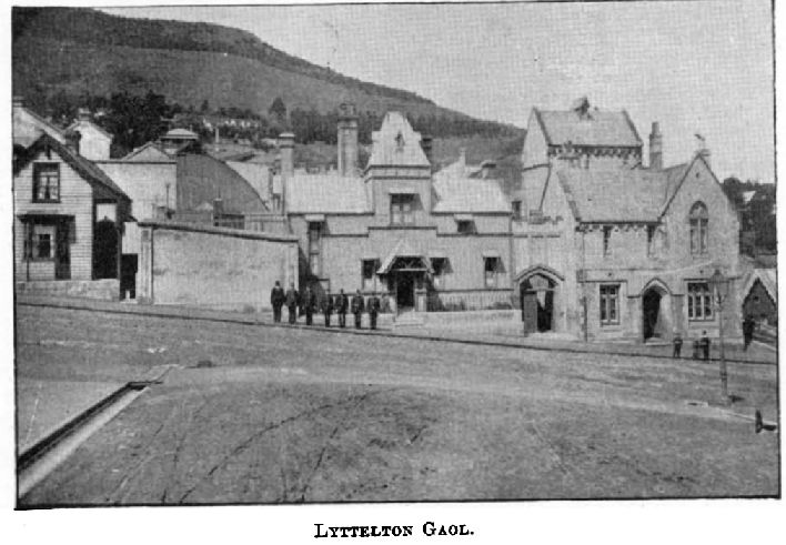
Interestingly, at least two drains constructed within the 19th century portion of Sumner Road had been constructed with locally cut and shaped red scoria blocks. Supporting this are newspapers references, including one mentioning the services of a mason to repair a drain after it was damaged by a cart (Press, 10/4/1872: 3). The use of this material is not unusual within the context of Lyttelton, as we have also found that an early drain (built in 1857) located within the Gaol complex was also constructed of red scoria. The drains found on Sumner Road were square with large red scoria blocks cut on the inner, top, base and side surfaces, but left uncut and rough on the outer sides. The use of these drains was evident as the base stones had well worn grooves cut by the water trickling through over time.

Looking down on the top of one of the drains. Image: M. Hickey.

Looking through the remainder of the red scoria drain while still in situ. Image: M. Hickey.

Rockfall remains a risk in some surrounding areas of the Bridle Path, but the path was used by a number of people in the immediate aftermath of the earthquake as both Sumner Road and the tunnel were closed. Recent works on the path for service renewal exposed a number of different stone and clay based track and fill layers. However, given the popularity and age of the track, the track was subject to many upgrades and repairs over time so these layers could be attributed to any phase of activity occurring in the 19th or 20th century. While we might not have too many subsurface finds that tell us about the settlers who used the track, the track itself is a recorded archaeological site and is a visible reminder of the challenge posed by the Port Hills.

The Bridle Path in 2020. Image: J. Whitmore.

A 20th century culvert with stone and clay fill around, and natural clay beneath. Image: M. Hickey.

By Megan Hickey and Lydia Mearns.

References

Amodeo, C., 2001. Forgotten Forty-niners: Being an account of the Men & Women who paved the way in 1849 for the Canterbury Pilgrims in 1850. Christchurch: The Caxton Press.

Height, J. and Straubel, C.R. eds., 1965. A History of Canterbury. Volume 1: T ed. Christchurch: Whitcombe & Tombs.

Lyttelton Times, 1851-1914. [online] Available at: https://paperspast.natlib.govt.nz/.

New Zealander, 1845-1866. [online] Available at: https://paperspast.natlib.govt.nz/.

Ogilvie, G., 2009. The Port Hills of Christchurch. Christchurch, N.Z.: Philips & King.

Press, 1861-1945. [online] Available at: https://paperspast.natlib.govt.nz/.

Star, 1868-1920. [online] Available at: https://paperspast.natlib.govt.nz/.

Follow the Red Brick Path

Recently we’ve been working in Lyttelton at the intersection of Canterbury and Winchester Streets for the installation of a replacement stormwater. While Lyttelton isn’t exactly over the rainbow, for archaeologists it is a pretty fantastic place to discover heritage and archaeology that has survived to the modern day. We have written about a number of sites in Lyttelton on the blog before, and there is always a good chance of encountering something beneath the ground in any project we’re involved in. The subject of the blog today is this particular find on the corner of Canterbury and Winchester Streets, which was a little different to our usual finds within the roadway. No lions, tigers or bears (oh my!), but instead, along with two rubbish pits and the corner of what was likely the original stone kerbing, we uncovered an earlier brick footpath just below the modern asphalt one. Tap your ruby slippers together and let’s go to 19th century Lyttelton to get a bit of context first.

Figure 1. Looking along Canterbury Street at the brick path (and the contractors at work!). Image: M. Hickey.

Both Canterbury and Winchester Street are part of the original town plan by Edward Jollie in 1849. Construction of the roads within the Lyttelton township began soon after their survey, but it was not until 1875 that the council finally agreed to fix the level of the street so that “the proper steps [could] be taken for forming the portion of Canterbury street between London and Winchester streets” (Amodeo, 2001: 148; Globe, 5/5/1875: 4, 16/6/1875: 3, 7/7/1875: 3; Press, 13/5/1875: 3, 14/5/1875: 4, 30/6/1875: 3; Star, 23/6/1875: 2). This work was likely necessary as sanitation issues were arising from residents throwing soap suds, vegetable matter, and refuse into the roadway of Canterbury Street (Press, 3/6/1875: 3). This would likely explain our two rubbish pits, although we are yet to do the analysis of these to see if the dates align. Although the Lyttelton Borough Council also commenced the construction of a footpath at this time, the threat of legal proceeding from H. Wynn Williams (the proprietor of the Albion Hotel, formerly located at modern site of Albion Square), whose section boundaries would be affected by the alteration of the roadway, stopped the footpath being completed at this time (Press, 22/9/1875: 3). Finally, in May 1891, the Lyttelton Borough Council adopted the suggestion made by the Foreman of Works that “the footpath in Canterbury Street should be laid down in brick” (Star, 5/5/1891: 4). Although no further information regarding the exact location of the brick footpath is recorded in the minutes of the Council meeting (which were printed in the local newspapers), it is likely that the section of the footpath in our project area was included in these works.

Figure 2. Detail from a photograph looking west along Winchester Street in 1901. William Hatherley’s store is visible on the corner of Canterbury Street along with the adjoining small cottage. More information on Hatherley below. Image: Rice, 2004: 46.

With regards to the property at the corner of Canterbury and Winchester Streets, evidence suggests that by at least May 1880 the premises were leased by Mr William Hatherly, who advertised his grocery store from premises on the “Corner of Canterbury and Winchester Street”, which he called “The People’s Store” (Star, 19/5/1880: 2). In 1890, the premise was advertised for sale, at which time it was described as comprising a “a large store and dwelling of seven rooms with cellarage” and also a “comfortable cottage of three rooms adjoining” (Star, 13/3/1890: 2). Hatherly later purchased the section he had been leasing since 1880 and shortly after advertised for tenders for the “erection of four rooms and alteration to present building, corner of Canterbury and Winchester Streets” (Lyttelton Times, 23/10/1891: 8). These alterations coincided with the Lyttelton Borough Council’s decision to have the footpath in Canterbury Street paved with brick, which suggests Hatherly may have altered the building to best align with the new street frontage.

The decision to pave the footpath with brick at the corner of Canterbury and Winchester Streets shows the important of the foot traffic in the area. While gravel footpaths were more commonly constructed in 19th century Canterbury, the use of brick-paved footpaths were more favourable in areas of heavy foot traffic as they were more pleasant to walk on and provided a better foothold in winter than smooth flagged or asphalted pavement (a very important consideration for Lytteltonians). Bricks were also favourable as they were easily laid, and also easily removed when it was necessary to lay or repair water-pipes or make connections with house drains. In England, brick footpaths were quite ornamental, often being laid in diamond or rosetta patterns (Hasluck, 1904: 76). While none of the bricks we found were quite that ornamental, it has been noted that only the best work would have the bricks at the corners of streets radiate around the street corner in a fan, rather than have two courses of bricks meet at right angles as was more common (Hasluck, 1904: 83).

The brick path exposed during works was a very short one to follow, comprising two sections at a maximum length of 3.5 and 3.8 m each. The path had been disrupted by services laid in the 20th century but the laying of the modern asphalt footpath directly on top of the bricks had done a great job at preserving the remaining sections. All of the bricks were marked with a ‘W’, the manufacturers mark for the Wigram Brothers brickmakers. Wigram Brothers began manufacturing and selling bricks in 1886 when they purchased the brickyard formally owned by Royse, Stead and Co. and the New Zealand Grain Agency Company and Mercantile Ltd in Heathcote (Akaroa Mail and Banks Peninsula Advertiser 9/7/1886: 3, Cyclopedia Company Limited, 1903: 292). “W” marked bricks stopped being produced in 1903 when Wigram Brothers merged with T. N. Horsley to form the Christchurch Brick and Tile Company (Press 14/7/1903: 1). The bricks at the corner were laid differently in more of an angled pattern to fit the corner. Although we could only see part of this section, they appeared to radiate out from the corner – more like the fan pattern described above.

Figure 3. Part of the south portion of the bricks, in straight courses. Most of this section was able to be left in place after the completion of the recent works. Image: M. Hickey.

Figure 4. Part of the northern section of the bricks, with a lot of fill material marking the service which cut through the pathway. Image: M. Hickey.

Figure 5. The brick path was just below the modern asphalt surface, as seen here. Image: M. Hickey.

Figure 6. The northern section of the path at the corner. The bricks here are angled to go around the corner rather than have two straight courses meeting at right angles – probably a mark of good brick laying. Image: M. Hickey.

Figure 7. Out of the ground and all cleaned up: one of the Wigram Brother bricks from the path. Image: J. Jones.

This all the information we have for now, as these finds are pretty recent and we’re yet to complete the report on the project. As the project was concentrated on the intersection of the two streets, we don’t know how much of the path remains along the rest of Canterbury Street, although we didn’t encounter it again on the northern side of the intersection. It was great to see that previous asphalting of the footpath kept the bricks in situ and in good condition for us to find later. We’re big fans of heritage fabric being left in place when there is no need to remove it to carry out a project, so it was fantastic that someone had come to the same conclusion in the past.

Megan Hickey and Lydia Mearns.

References
Akaroa Mail and Banks Peninsula Advertiser, 1877-1939. [online] Available at: https://paperspast.natlib.govt.nz/.

Amodeo, C., 2001. Forgotten Forty-niners: Being an account of the Men & Women who paved the way in 1849 for the Canterbury Pilgrims in 1850. Christchurch: The Caxton Press.

Cyclopedia Company Ltd, 1903. [online] The Cyclopedia of New Zealand [Canterbury Provincial District]. Available at: http://nzetc.victoria.ac.nz/tm/scholarly/tei-corpus-cyclopedia.html
d4.html.

Globe, 1874-1882. [online] Available at: https://paperspast.natlib.govt.nz/.

Hasluck, P.N., 1904. Road and Footpath Construction. Cassell & Company.

Lyttelton Times, 1851-1914. [online] Available at: https://paperspast.natlib.govt.nz/.

Press, 1861-1945. [online] Available at: https://paperspast.natlib.govt.nz/.

Star, 1868-1920. [online] Available at: https://paperspast.natlib.govt.nz/.

Rice, G.W., 2004. Lyttelton: Port and Town – An Illustrated History. Canterbury University Press.

Picture perfect – a gallery of archaeologist’s art

Today we would like to take you through some art work created by our team over the years. But this isn’t for your local charity art auction – these images illustrate the archaeological process we undertake on a daily basis. Long time followers of the blog and Facebook page (and any other archaeologists keeping tabs out there) might be familiar with some aspects of this process. However, the extent of the work that goes into an archaeological site from A to D (or Z if a particularly tricky site) is not something we explore often. Part of the reason for this is it often requires quite a bit of boring paperwork and long explanations of legislation. In order to avoid the elements of the process which might put you to sleep, here is generalised version of the typical archaeological process with pretty pictures alongside.

Step 1: Assessment of the project area

Before a single trowel goes into the ground, proposed earthworks which have the potential to disturb any recorded or yet to be recorded pre-1900 archaeological sites must go through an archaeological assessment. This assessment forms part of the paperwork required to apply for an archaeological authority (the legal document that allows earthworks to take place while protecting and/or mitigating damage for any archaeological material exposed) from Heritage New Zealand Pouhere Taonga. The risk of encountering archaeological sites, the possible sites types located in the project area and the impact of the works on potential sites are all included in the assessment. In order to assess these aspects, our historical researchers go to great lengths to source and uncover as much of the historical background of the property section or area which will be subjected to works. Much of this work focuses on historical sites of the 19th century as these types of sites form most of the work we undertake. If the historian is lucky they might encounter well-documented suburbs, families and buildings – making this part of the process relatively straight forward. Other projects may require many hours of painstaking research into archives, attempts to reconcile contradictory land parcels and transfers, exclamations over insufficient records and over-consumption of tea and coffee.

In the images below, we have a couple of colourful illustrations drawn by one of the resident historians. These drawings were done to assist the process of teasing out where the relevant historical occupation is located on a larger section. In an ideal world, this information would be neatly filed away in an easily accessible online resource – although in that world the robots may have already taken over our jobs if things were that easy.

An overlay of a land parcel subdivision on an aerial photograph with additional annotations…all to get to the bottom of where the house was located. Image: L. Mearns.

A colour coded sketch of a town section – useful for working out how subdivisions correspond to certificates of title. Image: L. Mearns.

Step 2: Field work

Granted the authority process went smoothly and the paperwork is all in order, it’s time for the works to begin. Our job as field archaeologists mostly deals with mitigation for works that have to take place such as demolition of buildings, new building construction, service repairs and so on. The fantastic work undertaken in the assessment process means the field archaeologist is pretty well prepared for what could be encountered during the works. Projects which have visible, often above ground archaeological sites (such as historic buildings or other structures) usually involve pre-recording of the archaeology before any work impacting the site. The images below show some of the notes and illustrations taken by one of our field archaeologists during the recording of a rather ornate building.

A rather elegant sketch of an ornate window. Useful for later reference and adding a touch of class to the field notebook. Image: K. Webb

This one could almost adorn an illuminated manuscript. Almost. Image: K. Webb.

I think someone missed their higher calling as an artist – look at that shading work on this sketch of a window dating to 1879. Image: K. Webb.

But until we perfect our ground penetrating sunglasses, we can never be too sure what will or won’t be uncovered below ground. Recording of below ground features, whether early Māori ovens, rubbish pits or brick barrel drains, must be recorded according to standard archaeological practice. This process often involves to-scale drawings such as site plans showing the locations of the recorded features, specific illustrations of complicated or noteworthy features and detailed drawings of layers of soil and features (known as stratigraphic drawings). The images below were drawn onsite during works and show examples of each type of drawing mentioned above.

A rather large but very neat site plan of historic house site, showing the location of the earthworks and recorded archaeological features. Every pile in its place! Image: R. Geary Nichol.

When your feature is so large it takes nine separate pieces of paper to record. This was one large brick floor recorded on a central city project. Image: H. Williams.

This stratigraphic drawing (featuring multiple layers of cultural material, large ovens and scattered artefacts) is a bit of a work in progress but demonstrates how complicated this recording can be. Image: T. Anderson and H. McCreary.

Step 3: Interpretation and reporting

At this stage all the works associated with the project are complete and the archaeologist can relax in the sun (or the June snow as it were) with a cold beer and contemplate the meaning of life, the universe and everything. Or at least that’s the fantasy after extensive recording and excavation in the field. The reality is that an archaeologist’s work is never done! All the artefacts, drawings and notes need to be ordered, analysed and turned into a report. Aside from being a requirement under the archaeological authority, the production of a report stands as a record of the work that was done, the archaeology that was exposed and the interpretations of the archaeologist/artefact analyst/other specialists. Such a record not only enriches our understanding of the past but also becomes a part of the historical record of the site in its own right (and is hopefully of great use to future researchers). Depending on the extent of the archaeological material found during the works, the report can be as labour intensive as the previous steps of archaeological process, requiring digitisation of the drawings produced onsite, detective-like interpretation of the features and analysis of the artefacts (sometimes hundreds, if not thousands of them!). The artefact analysis in particular is an important part of the process as we can often draw a lot of information about the date, spatial relationship of features and occupation from the artefacts found. This information can confirm, add to or contradict the historical research, and sometimes the archaeologist’s onsite interpretations. These post-field aspects of a recorded site are like a puzzle – we try to put the big picture together with the pieces that are available to us. Sometimes it’s a 50 or 100 piece puzzle, sometimes it feels more like the most difficult puzzle in the world – we don’t really get to choose.

Sometimes this interpretation process needs a few visual aids. The images below have been drawn by our artefact analysts to help understand the relationship between different archaeological deposits on a site and to assist with recognising the different features of an artefact.

Working out the spatial relationship between different archaeological deposits from the information recorded onsite and from the artefact analysis. Multiple depositions can be quite the headache. Image: M. Lillo Bernabeu.

A lot of different colours and patterns went into this interpretation sketch. Sometimes it takes a bit of creative colouring to make sense of the archaeology and brighten our day. Image: M. Lillo Bernabeu.

Who knew there were so many different parts to a shoe, aside from a cobbler I guess. Image: J. Garland.

Lovely teacup handle types. Image: J. Garland.

We hope you’ve enjoyed your digital sojourn through our gallery of archaeological creations and have learned a bit more about the work we do behind the scenes of all those glamorous photographs. We may even be able to start a side business creating high end art after this…or at least deserve some of the gallery wine and cheese.


Megan Hickey

The Trooper

Ceramics have been decorated to commemorate a range of events, people and places since long before the 19th century. The practice is particularly tied to British royalty, with some rather intense results. While tankards, jugs, plaques, mugs and miniature wares are most commonly decorated for commemorative purposes, a number of different ceramic types could be used in this manner (Perry 2011). The subject of the blog today is inspired by two mustard jars from Christchurch that commemorate events from the Crimean War. The Crimean War occurred from 1853 to 1856. Caused by the failing Ottoman Empire and power struggles between countries over religious rights of access to the Holy Land, two key parts of the war are depicted on these household artefacts, the Siege of Sevastopol (also known as Sebastopol) and the Battle of Balaklava (or Balaclava; Goldi Productions Ltd 1996 & 2000Wikipedia 2017).

Source caption: “Episode of the Siege of Sebastopol During the Crimean War in 1855”, dated 19th century and credited to Adolphe Yvon. Image: Wikipedia 2015.

The first of these came from the large Justice Precinct site in the city centre. It was decorated with polychrome transfer print in a style often identified as ‘prattware’. Prattware refers to polychrome underglaze transfer printed scenes that were associated with the manufacturers F. & R. Pratt & Co. Ltd (Perry 2010). This particular jar featured a scene known as the ‘The Fall of Sebastopol 8th Sept. 1855’ (Transferware Collector’s Club 2005-2017). This scene refers to one of the classic sieges of the Crimean War, which aimed to capture the significant Russian naval base in the port of Sevastopol, on the Black Sea (Bunting 2017).

Mustard jar decorated with the Fall of Sevastopol.

The print depicts and names Sir Harry Jones, the famous British military man who served in the Crimean War as commander of the British forces at the battle of Bomarsund and of the Royal Engineer forces at the Siege of Sevastopol (Transferware Collector’s Club 2005-2017). Most descriptions of this pattern presume that Sir Harry Jones is the figure on the stretcher in the scene, although there is no record of his being wounded during the battle. The full title of the pattern includes the date 8th September 1855, when the Battle of Malakoff occurred and the Russian forces began to withdraw (Atkinson 1911: 451-453; Transferware Collector’s Club 2005-2017).

The second mustard jar base was found on a residential site just outside the city centre. The whiteware jar had a polychrome transfer printed design depicting a battle and the words “The/…OON/CHAR…” around the base. This would have formed the full phrase: “THE DRAGOON CHARGE” (Transferware Collector’s Club 2005-2017). This print depicts the Battle of Balaklava fought on 25 October 1854 as a part of the Siege of Sevastopol during the Crimean War. The Battle of Balaklava was a Russian assault on the British allied supply base that involved the famous Thin Red Line military tactic and the infamously deadly Charge of the Light Brigade (Wikipedia 2017).

‘The Dragoon Charge’ underglaze print on the Prattware mustard jar.


Source caption: “The Russian camp at the Genoese Castle, Balaklava.” Image: Roger Fenton/Getty Images, The Telegraph.

Although no maker’s marks were evident on the base of either jar, examples of the same printed Prattware are attributed to the manufacturers John Thomas and Joseph Mayer. Thomas and Mayer manufactured pottery in Longport, Burslem, Staffordshire between 1842 and 1855 (Kowalsky & Kowalsky 1999: 274). The date range for the operation of the Thomas and Mayer company and the commemorative nature of the prints suggests a manufacturing date in the 1850s, possibly as early as late 1854 to 1855. This would have taken place while the Crimean war was still ongoing.

Although little remembered today, the Crimean War is often described as the “first truly modern war” (Groll and Frankel 2014). With the advent of new technology, industry and weaponry, the resulting high casualty rate marked this event as a significant moment in the mid-19th century. In addition to this, the perceptions of the war were shaped by real-time journalistic coverage and photographic documentation by Roger Fenton. Due to the process involved in setting up and taking photography at the time, Fenton was limited to producing images of still (sometimes staged) moments in between the carnage. Depictions of the fighting seem to be limited to paintings and prints made during the war by artist-correspondents or after the war.

Source caption: “Roger Fenton himself dressed in a Zouave uniform holding rifle. Zouaves were crack infantry units, originally composed of Algerians. During the Crimean War, Zouaves served with the French Army, allies of the British. Fenton’s self-portrait in the costume indicates the high regard the British felt for the Zouaves.” Image: Roger Fenton/Getty Images, The Telegraph.

Source caption: “Two versions of the widely-acknowledged ‘first iconic war photograph’ entitled The Valley of the Shadow of Death. The lower one shows cannonballs on the road whereas above shows the road clear of ammunition. Historians have concluded that Fenton may have moved the cannonballs into the road to enhance the image. An alternative view is that soldiers were gathering the missiles for re-use and had thrown them onto the road to make them easier to collect.” Image: Roger Fenton/Getty Images, The Telegraph.

Source caption: “British soldiers pose for a photographs during a break.” Image: Roger Fenton/Getty Images, The Telegraph.

Polychrome transfer printed scenes like this were used on ceramic food containers throughout the latter half of the 19th century, although they are not common on Christchurch archaeological sites. The jars are an example of commemorative objects available for consumption in the wake of significant events. The participation of British soldiers in the Battle of Balaklava in particular was seen as an example of some of the finest heroic fighting of the war and many depictions of this heroism were created in art and literature (Bunting 2017). These kinds of physical reminders of formative events in national identity have been noted elsewhere in discussions of commemorative products depicting the 1899 South African War, particularly with regards to the connections between colonial and national ideologies (Lucas 2004). Although New Zealand was not directly involved in this conflict, British soldiers who fought in the war later emigrated to New Zealand (New Zealand Crimean War Veterans 2017). Such an event was part of the collective memory of 19th century British national identity, as evident in other depictions of the battle such as paintings and in the poem “Charge of the Light Brigade” by the English poet Alfred, Lord Tennyson. As such, the presence of objects commemorating the Crimean War in 19th century New Zealand archaeological sites demonstrate these links to important historical events.

The Thin Red Line by Robert Gibb, 1881. Image: Wikipedia 2017.

The remembrance of aspects of the Crimean War continued through to the modern era. Lord Tennyson’s poem in particular formed the platform for later adaptations of and references to the event. The Charge of the Light Brigade was immortalised on screen in 1912, 1936 and 1968. Each version varies greatly in how it depicts the events of the war, in line with the time period and popular movie styles of the period. The poem has echoes in modern pop culture as Lord Tennyson’s poem formed the basis of the 1983 Iron Maiden song ‘The Trooper’ and references in movies and TV shows from Saving Private Ryan to Top Gear to The Fresh Prince of Bel-Air.

Megan Hickey

References

Atkinson, C. F., 1911. Crimean War. In Chisholm, H. (Ed). Encyopaedia Brittanica 7 (11th Edition). Cambridge University Press, Cambridge.

Kowalsky, A and Kowalsky, D. 1999. Encyclopaedia of Marks On American, and European Earthernware, Ironstone and Stoneware 1780-1980. Schiffer Publishing Ltd. Atglen.

Transferware Collector’s Club, 2005-2017. The Dragoon Charge – Balaklava [online] Available at: http://www.transcollectorsclub.org/tcc2/data/patterns/d/the-dragoon-charge-balaklava/ [Accessed 05 May 2017].

The Big House in a little town

The degree of civilisation in a society can be judged by entering its prisons

– Fyodor Dostoevsky

One of the challenges faced by any new colony is what to do with the non-conformists, renegades, and criminals. The ideal, of course, is that your new paradise will be carefully designed to have eliminated these undesirable elements. The reality, however, is far from the ideal. The first lock-up in the Canterbury (consisting of three blockhouses) was located in Akaroa, a significant distance away from the growing towns of Christchurch and Lyttelton (Gee 1975: 5). These blockhouses appear to have been used until John Godley arrived on the scene in April 1850 and was appointed as the resident magistrate of Lyttelton (Gee 1875: 7). With his appointment, the location of the lock-ups/gaols moved to the fledgling port-town instead. The earliest gaols in Lyttelton were improvised and, for some enterprising fellows, rather portable. One particularly slapstick story of a runaway gaol involves some opportunistic pranking by the future gaol warden, Edward Seagar:

One night the prisoners in the lock-up, a flimsy, A-frame construction, took up the floor boards, lifted the building and walked away with it. Seagar arranged ropes and stakes in such a way that the escapees unknowingly headed towards the police station further down the hill (Young 2014).

The landing of passengers from the Charlotte Jane, Randolph, Cressy, and Sir George Seymour in Lyttelton c. 1850. Plenty of open space for pranks. Image: Alexander Turnbull Library.

The landing of passengers from the Charlotte Jane, Randolph, Cressy, and Sir George Seymour in Lyttelton c. 1850. Plenty of open space for pranks. Image: Alexander Turnbull Library.

The first permanent gaol buildings in the settlement were constructed between 1851 and c.1857-1861 on Oxford Street, using both hired and prison labour (Gee 1975: 8, 10). Later buildings followed the design of B. W. Mountfort, who also designed the Sunnyside Lunatic Asylum (Heritage New Zealand 2016). The decision to construct a gaol in a small town like Lyttelton may seem odd to us today, but the reasoning was fairly straightforward. Lyttelton was the bigger town at the time and the new buildings replaced the earlier makeshift prisons near the contemporary police station and court (Gee 1975: 10).

The Lyttelton Gaol, date unknown. Image: Cyclopedia Company Limited 1903. A later image of the gaol c. 1900 can be viewed here.

The Lyttelton Gaol, date unknown. Image: Cyclopedia Company Limited 1903. A later image of the gaol c. 1900 can be viewed here.

Early conditions in this gaol, according to some commentators, had something of a Dickensian feel:

The early days were those of the cat [of nine tails whip] and the triangle, of the 70lb dragging irons, the days of scanty clothing, poor food, the days when the warder was king (Gee 1975: 2).

Others have argued that, in light of the standards at the time, the treatment of the prisoners was not quite as cruel as it may seem to us today (Gee 1975: 10). Conditions were hampered by one major issue which arose in this early period – the swelling gaol population. This population growth was exacerbated by the incarceration of debtors and the mentally ill. The housing of the mentally ill at the gaol was particularly concerning to many (Young 2014). The young townships of Lyttelton and Christchurch simply did not have the facilities to deal with these patients at the time. To their credit, it was intended that the patients be housed in the new Christchurch Hospital, until there was a furore in response to this plan (Gee 1975: 35). The population pressures eased with the construction of Sunnyside Asylum in 1863, and the opening of the prison in Addington in the 1870s (Gee 1975: 30, 87).

Sunnyside Lunatic Asylum. Image: Te Papa O.034082.

Sunnyside Lunatic Asylum. Image: Te Papa O.034082.

Part of the Addington Prison complex, c. 2005. Image: Wikimedia Commons. The prison is now a backpackers.

Part of the Addington Prison complex, c. 2005. Image: Wikimedia Commons. The prison is now a backpackers.

The position of the gaol within town life is quite interesting. As illustrated in the image above, the large Gothic style buildings were quite a dominating feature of the town. In addition to this, the prisoners were involved with a number of town works (discussed further below) and services which ensured a high public presence (Heritage New Zealand 2016). These services included a printing shop, a laundrette for the Lyttelton Hospital and Orphanage and the Immigration Department, and a baking contract for the orphanage (Gee 1975: 17). However, one comment from a resident regarding the communities’ view of the gaol (made after the demolition of the gaol in the 1920s) is particularly telling:

We never thought about the gaol.  We just knew it was there and that was it. But many people couldn’t have been pleased about it because there are few photographs of it and no paintings as far as I have found (C. Fletcher in Gee 1975: 87).

A rather macabre aspect of the prison, which feels particularly repugnant to us today, is that between 1868 and 1918 seven men convicted of murder were executed at the gaol. This was an aspect of the gaol that was a source of curiosity for some of the younger residents, but of dread for most. One resident stated: “In a little place like Lyttelton the knowledge of an impending execution used to hang like a pall over the whole town” (I. Gray in Gee 1975: 47). It is quite a stretch for me to imagine a community continuing with their daily lives in the anticipation of such an event. Executions appear to have been so entrenched in the town’s psyche that despite the fact that the bell did not toll for the last execution in 1918, many residents insist they remember it ringing (Gee 1975: 47).

A poem by Basil Dowling. The role of the hangman was a necessary part of the justice system, which carried a heavy stigma for the men who did the job. There are a number of cases where officers had to smuggle the hangman in to avoid the curiosity and/or anger of the general public.

A poem by Basil Dowling. The role of the hangman was a necessary part of the justice system, but carried a heavy stigma for the men who did the job. There are a number of cases where officers had to smuggle the hangman in on the eve of the execution to avoid the curiosity and/or anger of the general public.

The archaeological legacy of the prison and prisoners remain visible in many aspects of the town today. All that remains of the gaol itself are concrete retaining walls, a small block of cells, pedestrian pathways and concrete steps. These remains are an important archaeological site, particularly as they are demonstrative of some of the earliest use of concrete in New Zealand (Heritage New Zealand 2016).

The remaining cells and concrete walls of the prison. Image: A. Bulovic, 2013 Peeling Back History.

The remaining cells and concrete walls of the prison. Image: A. Bulovic, 2013 Peeling Back History.

However, we can also see the influence of the gaol on the Lyttelton settlement through other features of the town. Prisoners sentenced to hard labour were part of gangs put to work on public works, such as road formation and retaining wall construction. In particular, the red volcanic retaining walls constructed during this period have been described as a distinctive part of the townscape. Unfortunately, as with much of Lyttelton’s heritage, a number of these walls have been repaired or replaced after the damage from the earthquakes.

Earthquake damaged walls at the corner of Coleridge Terrace and Dublin Street. Image: M. Hickey, 2015.

Earthquake damaged walls at the corner of Coleridge Terrace and Dublin Street. Image: M. Hickey, 2015.

 The newly constructed concrete wall on Sumner Road, with partial re-facing using the volcanic stone from the demolished wall. The re-facing will occur on as many of the key retaining walls across the town, as funding allows. Image: M. Hickey, 2016.

The newly constructed concrete wall on Sumner Road, with partial re-facing using the volcanic stone from the demolished wall. The re-facing will occur on as many of the key retaining walls across the town as funding allows. Image: M. Hickey, 2016.

A collapsed wall at 61 St Davids Street. Image: M. Hickey, 2016.

A collapsed wall at 61 St Davids Street. Image: M. Hickey, 2016.

The same wall after deconstruction and reconstruction work (all completed by hand). Image: M. Hickey, 2016.

The same wall after deconstruction and reconstruction work (all completed by hand). Image: M. Hickey, 2016.

The port also benefited from convict labour in the form of reclamation construction and wharf building (Gee 1975: 17). Another notable site of works is the fortifications at Ripapa Island, which were constructed in the 1860s and 1870s by the Hard Labour Gang and were even used to house some prisoners (Gee 1975: 22). Prisoners housed on the island reportedly included members of the Parihaka resistance movement in Taranaki in 1880s (Donna R 2014). These men are remembered today during a service on the 5th of November each year and a memorial at Rapaki (Lyttelton Community House Trust 2013).

In many ways, the Lyttelton Gaol was a product of its time; the morality of Victorian Britain, the realities of a new colonial land and the challenges of a growing society. However, the legacy of the gaol should not be limited to a grim spectre of past principles. Prisoners made a considerable contribution to the development of the town through the construction of infrastructure. Despite the recent changes to the townscape, the influence of the gaol remains a visible part of Lyttelton’s heritage.

Megan Hickey

References

Gee, D. 1975. The Devil’s Own Brigade: A History of the Lyttelton Gaol 1860-1920. Wellington: Millwood Press Ltd.